

Oddities and Wonders as Seen from Space
Having basically grown up alongside personal computing and the internet and being imbued with a great deal of wanderlust I am particularly suited to still treat commonplace innovations such as Googlemaps and Streetview with the wonder you might expect from a small child. Also, I am an incurable geography nerd. Still though, even for those who are less obsessed with maps than myself these websites offer some enlightening entertainment.
If, like myself, you are fortunate enough to still have grandparents then here is a fun activity. Pull up Googlemap and have them tell you where they used to live. You can cut to streetview and, with a little luck, find the apartment they lived in when they were first married. You'd be surprised what kind of stories that will stir up and how amazed they are to see their old stomping grounds. If you're more inclined to test your survival/geography skills there is Geo-Guesser which deposits you somewhere in the streetview world and its up to you to figure out where you are. It builds character.
More simply than this, the aerial imagery available from Googlemaps and Bing maps provides one with an amazing opportunity to see the world from a perspective totally unimaginable to most people throughout most of human history. Try this: turn the labels off of aerial mode and see if you can find your way around. You'd be surprised what you might find. I am always struck by the magnitude and meaning of man's ability to shape the world around us. Here are some of my favorite finds. An uncontrolled picture isn't quite sufficient to capture the scale of some of these features so I encourage you to follow the coordinates and explore for yourself.
I call these strange finds accidental wonders of the world. Some are impressive in their own right and some are just symbols for how we are changing our environment.
I Drink Your Milkshake
(37.350919,-100.645924)
I first noticed this pattern when doing research on landcover change. This bizarre needlepunch is what it looks like to "drink the milkshake." These are oil wells in the Permian Basin of West Texas. Some are active, most are defunct, some are experiencing a second life due to fracking. I was amazed at the horizontal scale of fossil fuel production.
Lost Cities of Appalachia
37.620758,-81.936035
Again stemming from my land cover research, this through me for a loop. Cities look pretty distinctive from remote sensing or satellite imagery. The grey pavement blob in the bottom right is Winston-Salem, NC. Most cities invariably look like grey pavement blobs from far enough away. The problem is that Eastern Kentucky and West Virginia, two of the least populated places in the eastern USA are covered in sizable grey blobs. What are these lost cities of Appalachia I wondered?
Well...It aint Machu Picchu
When I explored the aerial imagery to figure it out I nearly wept. This is what mountain-top removal mining looks like. This is the scale at which it is conducted.

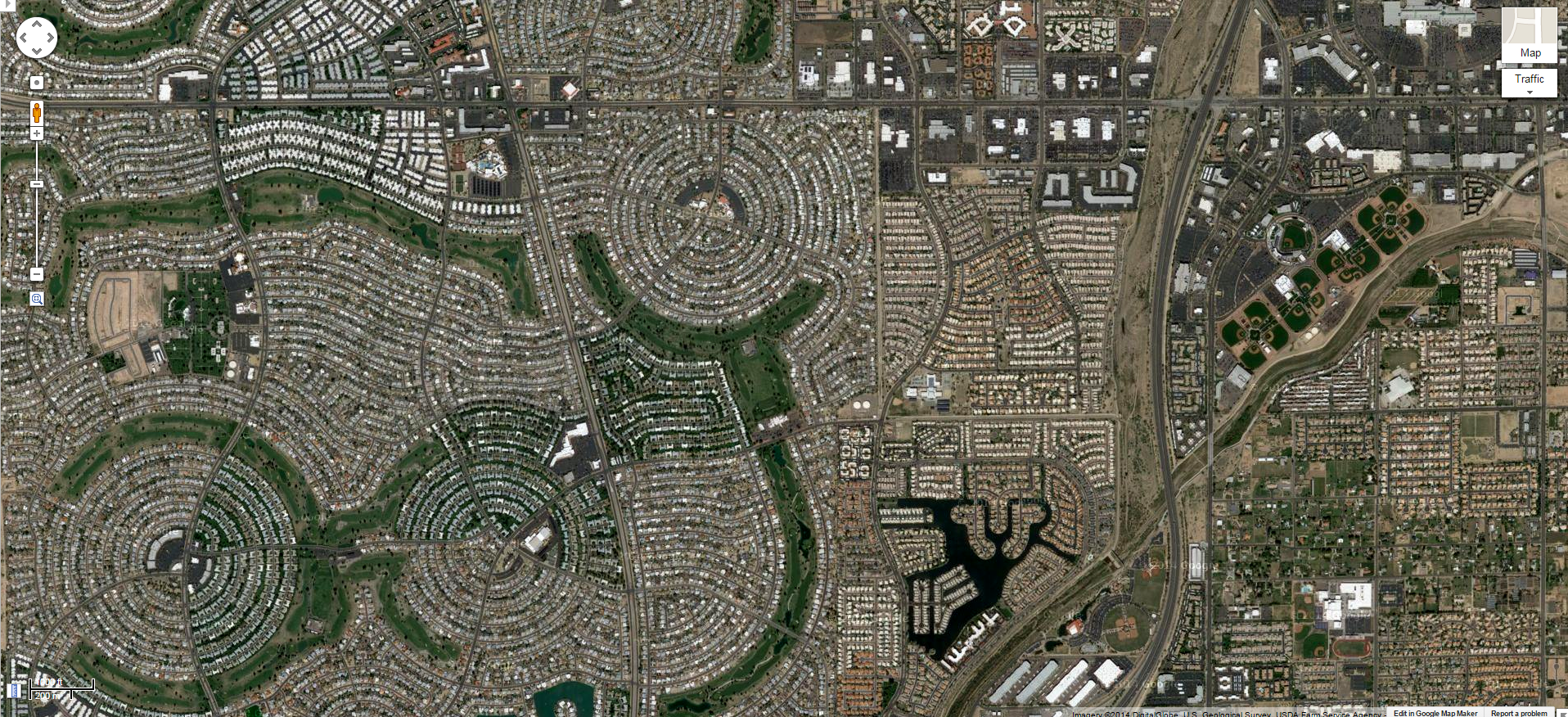
Nazca Lines of New Mexico
“The grid is the most courageous act of prediction in Western civilisation. The land it divides, unoccupied. The population it describes, conjectural. The buildings it locates, phantoms…”
35.257955,-106.79271 Well maybe not so courageous here. Maybe just presumptuous.
I think the bizarreness of this next image is best understood alongside this street-map. As far as streetmaps go, this might as well be any subdivision anywhere out west. But this is merely part of the puzzle. Here is the same location as an aerial image.
Miles and miles of ghostly empty streets are carved into the desert north-west of Albuquerque. If fully developed, tens of thousands of people could occupy this space. I haven't been able to ascertain exactly what happened here but this ghost-town configuration would appear to be related to the development of nearby Rio Rancho Estates, NM. It would appear, according to Rio Rancho's website, that there are still plans for filling in these blanks. If anyone can explain the story behind this place I'd love to hear it.
Terra-forming the Western Desert
33.61805,-112.291946 Sun City, AZ
I don't think this is exactly what Ebeneezer Howard had in mind but you can see the inspiration. What's amazing in this image and also a little terrifying is the efficiency with which we can alter one landscape to mimic another. Much like a science fiction story we colonized and terraformed the western desert as though it was an inhospitable alien planet.
What the World's Largest Airforce Looks Like When it Retires

32.151657,-110.829923
It's amazing what we have access to that the Soviet government would have paid top dollar for in spies or satellites decades ago. This is the 309th Aerospace Maintenance and Regeneration Group or AMARG. It's more commonly known as the boneyard. Given Tuscon's arid environment, the military decided, back in 1946, that it would be an ideal location for storing mothballed planes, spare-parts, and retired aircraft. I'm not sure retired is quite the correct word here. There is something to be said about the might of a military force simply be measuring what it throws away. Besides being a fascinating tour of American military equipment, the boneyard is amazing because of its mind-blowing size and capacity. Here is a larger view with parts of Tuscon for comparison.
The highlighted area is the boneyard. The building in the middle and airfield is Davis-Monthan Air Force Base. The rest is Tuscon, AZ. For perspective the highlighted area is about 200 acres or .3 square miles.
Here's a fun fact about the boneyard. It contains over 3,000 intact mothballed warplanes. That means if they were to be stolen by Carmen Sandiego she would possess the 3rd largest airforce in the world.
America's Sarlacc Pit
37.176791,-116.046418
The internet tells me that this 100 meter deep pit is not, in fact, the dreaded Pit of Carkoon. This is the Sedan Crater. It was created in 1962 by the Sedan nuclear test. In other words the result of a 104 kiloton thermo-nuclear bomb detonated 200 meters underground. That's 7 times the magnitude of the bomb dropped on Hiroshima for anyone who's counting. Ironically, this test was part of something called the Plowshare Program which aimed to determine if nuclear weapons could be re-purposed for civilian purposes like, I don't know, digging really massive holes. It turned out not to be feasible.
While it was pretty efficient at moving dirt (as in 11 million tons of it) it was also efficient at irradiating the continent. In some ways Sedan was the high water mark of atomic surface tests, demonstrating their detrimental impacts. Someone should probably Do The Math to see if the 10,000 yearly visitors to Sedan are enough count it a Plowshare success.
Besides Sedan Crater, the surrounding countryside of Yucca Flat was the testing ground for 739 atomic tests.
Yucca Flat, and Sedan Crater in particular, are so similar to a moonscape that Apollo astronauts actually trained here.
If you have some amazing unknown wonders I'd love to see them. Feel free to share them in the comments.